The Swartberg is the mightiest mountain range in the Western Cape, with peaks up to 2400 metres, fantastic ravines, gorges and poorts, amazing mountain passes, lost corners and a history as rich as its flora and fauna. The mountains frame the northern edge of the Klein-Karoo, their mighty peaks and slopes dark and swart against the northering sun.The mountains and the Klein-Karoo provide a playground for tourists -- there are ostrich farms, wildlife parks, the Cango caves, endless fascination for explorers, and a richness of facilities and activities that's as good as you could find anywhere.
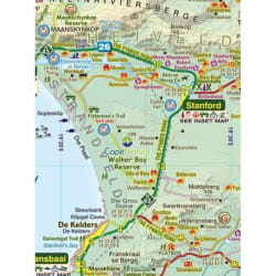
- All roads from National Highways to minor gravel roads are shown; the many classifications that indicate the quality of each road help you plan your r
- No less than 28 mountain passes are shown -- all are public roads!
- Distances are clearly shown; comprehensive 4 x 4 information.
- GPS coordinates in DD MM SS format are provided for every road-junction.
- All tourism facilities and accommodation establishments are shown in the out-of-town areas; there are insets of the major towns.
- The map links to our maps of the Baviaanskloof, the Garden Route, Overberg and the Tankwa-Karoo.
- A1 double-sided full colour map
- Scale 1:160 000 (6.25cm = 10km) 20m contours; relief shading
- 5' Long/Lat grid
- Coords in DDMM.SS format at every road-junction
- WATERPROOF and TEAR RESISTANT in plastic sleeve